Historically there were approximately 50 ancient parishes in this area. This is a list of where they were located and a little bit of information about them. Many ancient Parish Registers are still held and you can see a full list online. If you want to find out more general information about the history of the Church of Ireland there is an overview at Wikipedia.
| Buttevant Area: Broheny(Churchtown), Cooliney, Imphrick, Kilmaclenine, Lackeen, Liscarroll, Bregouge, Ballyclough, Kilbroney |
| Castletownroche Area: Wallstown, Ballyhooley, Monanimy, Nathlash, Carrigdownane, Kilcummer, Bridgetown |
| Doneraile Area: Farahy, Cahirduggan, Templeroan, Clenor |
| Kanturk Area: St. Peter’s, Drishane(Millstreet), Dromtariffe, Clonfert(Newmarket), Kilshannig, Castlemagner, Kilcorney Kilcorcoran, Kilbrin, Subulter, Clonmeen, Rosskeen |
| Mallow Area: St. James, (St. Anne’s), (St. Mary’s), Rahan, Killeens, Mourneabbey, Carrigamleary, Donoughmore, Dromdowney |
| Charleville Area: Aglishdrinagh, Ballyhea, Kilbolane, Knocktemple, Tullylease, Ardskeagh, Rathgogan, Shandrum |
| As yet unidentified locations: Kilgrogan? Kilroe? |
There follows information about each of the parishes:
Aglishdrinagh
This was a parish about three and a half miles south of Charleville on the Buttevant Road. Lewis lists it as a Rectory. There is evidence of an ancient church.
Ardskeagh
Two miles south east from Charleville it is listed by Lewis as a Rectory, but is looked after by a neighbouring Parish. There was a glebe and site of a church in his day.
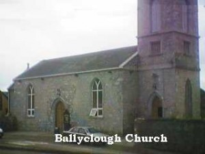
 Ballyclough
Also known as Lavan and about four miles north west of Mallow. The church is still intact having been recently refurbished as a Funeral Home. The graveyard adjoining the church is maintained by the County Council. The Parish records are in the keeping of Mallow Union.
Ballygrady
There is some confusion as to the exact location and naming of the plethora of burial grounds near Kilbrin. Ballygraddy graveyard is marked on the ordinance survey at a cross roads on the Kilbrin to Liscarrol Road. One report is that the parish church for Liscarrol was located here, another local view is that there was never a church on the site.
Ballyhea(Charleville)
This is two miles south east of Charleville. It was once an important parish but even in the 1800’s the church was a complete ruin (Lewis)
Ballyhooley
Although the parish is now joined with Fermoy Union and is very active it was once linked with Castletownroche in our Parish area.
Bregouge
This is one mile north west of Buttevant. There is no record of a church or glebe but it was a rectory in the last century.

Bridgetown
This is the site of an ancient Priory of the congregation of St. Victor where the Awbeg river joins the Blackwater. In 1835 it was made a distinct Parish with its own rector
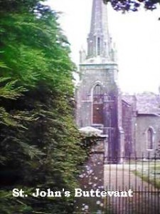
 Buttevant
St. John’s Church is officially closed but still used for occasional services. It is maintained by a group of trustees known as the ‘Friends of St. John’. The Parish records are largely intact.
TOP OF PAGE
Caherduggan
Three miles south west of Doneraile on the river Awbeg. After a chequered history the parish was united to Doneraile in 1806. The church was built in the reign of Charles II.
Carrigamleary
About four miles to the east of Mallow on the Fermoy Road. At one time it was part of Rahan, which is directly across the Blackwater river. The ruin of an obviously fine church built in the mid 1800’s can be seen just off the main road. Directly across the road is the ruin of the gate lodge of Carrig Castle with interesting arched windows.
Carrigdownane
Five miles from Mitchelstown on the road from Kildorrerey to Fermoy. Lewis says the church is in ruins and the Parishioners attend Nathlash.
Castlemagner
Three and a half miles east of Kanturk the church was recently closed and some registers are available.
Churchtown (Bruhenny)
Three miles west of Buttevant the graveyard here with the ruin of the medieval church is now famous as the resting place of the actor Oliver Reed. This church was replaced in the 1800’s by another one about a mile south west of the town by the Percival family the Earl’s of Egmont and landlords of the area. This new church lasted for only a few decades before being abandoned.
Clenore
Two and a half miles south of Doneraile the church was built in 1811 near an ancient ruin. It is now a ruin but the walls and tower are still standing and the delicately traced stone of the windows is still intact. The attached graveyard is still in use.
Clonfert (Newmarket)
Trinity Christ Church Newmarket was built in 1826. It was closed many years ago.

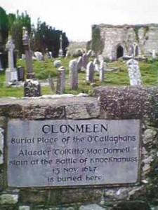
Clonmeen
Two miles south east of Kanturk on both banks of the Blackwater. There was a church and rectory here in the last century (Lewis)
Cooliney
On the road between Charleville and Liscarroll. There was a ruined church and a graveyard in Lewis’s time.
Donoughmore
This is on the Cork to Kanturk road about twelve miles from Cork. There was a church and glebe, the church only being closed in recent times.
Drishane (Millstreet)
The church was a large one with a square tower in the town. It was built in 1798 by J. Wallis of Drishane Castle and was closed many years ago. The graveyard is well maintained and the tower of the church stands as a monument there.
Dromdowney
Three miles west by north from Mallow and linked to Ballyclough. There is no record of a church building.
Dromtariffe
This is on the Mallow to Killarney road just north of Millstreet. The church is still in relatively good repair having been sold to a private owner.
Farahy
This church which is near Kildorrerey was sold to a private owner some years ago and is maintained in excellent repair. It is a the focus of a summer school celebrating Elizabeth Bowen, the Novelist.
Imphrick
Four and a half miles south of Charleville near the Buttevant Road in the middle of a field. The walls of the ruin are still standing showing a small church surrounded by a graveyard.
Kanturk
The church is on the northern outskirts of the town on the Freetown road and is in good repair having been handed over to the County Council some years ago. It replaced the more centrally placed church built when the town was founded in the 18th century.
Kilbolane
Five and a quarter miles from Charleville on the Rathkeale Road. The church was built in 1832.
Kilbrin
This is just east of Kanturk. The ancient church is no longer there but a graveyard marks the place. Another church was built church built at Ballygraddy in 1788 for the parish.
Kilbroney
Just north of Buttevant on the Charleville Road it has been linked to Buttevant for a long time. There are the ruins of a church in the burial ground (Lewis)
Kilcorcoran
Two miles from Kanturk on the Newmarket road. It was totally surrounded by Kilbrin but is described by Lewis as an important cure which paid well. He says there are the ruins of a church in the burial ground.
Kilcorney
Three miles south of Millstreet. Lewis notes a vicarage but no church.
Kilcummer
Just south east of Castletownroche. There is the evidence of a church in the graveyard. In his day Lewis noted the ruins of an ancient church, probably much as it is now.
Kilgrogan
This is referred to the the current Church of Ireland Directory but I can find no other evidence of it.
Kilmaclenine
Three miles from Buttevant on the Liscarrol to Mallow Road. There are the ruins of an ancient church dedicated to St. Colman. This is a most interesting site with a fascinating history having been a tannery town founded in the 13th century by either the Norman Barry family or the bishop’s of Cloyne, who later disputed ownership of it.
Kilroe, Kilmanloe, Scarlane
A suburb of Kanturk in Kilbrin Parish. There is no evidence of any church.
Kilshannig
Three miles from Mallow just south of the Blackwater. This beautifully proportioned and quite large church is only recently closed and converted into a craft center.
Knocktemple
Ten miles south west of Charleville on the road from Newcastle to Mallow. The church for this was in Kilbolane.
Lackeen
One and a half miles west of Churchtown off the Liscarrol Road a short way back from the Awbeg River. It is now only accessible through a farm yard and some fields. There are the partial walls of a ruin and a graveyard. Probably originally a monastic foundation it was later linked to Churchtown.
Liscarroll
The church for this parish was at Ballygraddy on the borders of Kilbrin. However see note under Ballygrady.
Mallow (St. Anne’s)
Now a ruin in the grounds of St. James’ it was the previous parish church.

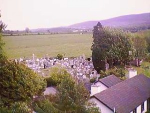
Monanimny
Five miles from Mallow on the Blackwater just across the river from Kilavullen. The adjoining picture shows all that is left now as seen from the top of Monanimy Castle. The church was built in 1810 on the site of a monastery.
Mourne Abbey (Ballinamona)
This church, just south of Mallow on the Cork Road, has been closed for some years but is still in reasonable condition.
Nathlash
One mile from Kildorrerey. The church was at Rockmills and built in 1811. Its records are with Mallow Union.
Rahan
Just outside Mallow on the Kilavullan Road. The church was built in 1788. It also had a Methodist meeting house and the remains of an older church (Lewis)
Rathgogan
This is the old parish in which Charleville was built.
Rosskeen
Three miles from Kanturk on the road to Mallow. No evidence of a church.
Shandrum
Two and a half miles from Charleville on the Newmarket Road. There was a vicar but the services were held in the school house (Lewis)
Subulter
Three miles east of Kanturk and for all purposes part of Kilbrin.
Templeroan (Shanballymore)
This has always used Doneraile Church.
Tullylease
Seven miles from Charleville on the Newcastle to Kanturk Road. There is an ancient church and burial ground but services in Lewis’s day were held at Tullylease House.
Wallstown
Two and a half miles from Doneraile on the Castletownroche Road. There was a large glebe house in which the services were held. There are the ruins of an older church at Wallstown House.
Sources of information:-
Church of Ireland Directory
Lewis Typographical Survey
Local knowledge
